Welcome!
The purpose of this site is to provide more information about the Wolkberg Wilderness Area.We hope that more people will [responsibly] visit the Wolkberg more often.
Wolkberg is good for your soul!
Safety
Due to some tragic safety incidents in the Wolkberg, this safety section has been inserted at the top of this page. Please exercise common sense and caution. Some tips are below:- Water: Make sure that you have enough water (more on this below). Unless you are highly experienced, you should always plan to camp by a drinkable water supply (next to a clean stream).
- Contingency Plans: Have contingency plans, and be willing to "give up" on your intended route if necessary and turn back the way you came. Set a half-way point/time - when you reach the half-way point/time then check whether you will clearly be able to reach your destination. If not, then turn back the way you came and return to your previous campsite (it is assumed that you camped near a drinkable water supply). This principle also applies to "half-water" - if you are on "half-water", then check that you will clearly be able to make it to your next water-point without running out of water, otherwise turn back to your previous water point. Ideally you should have a good deal more water supply than needed (either carried on you, or nearby on your route), and should never come even close to running out of water (dehydration is one of the most dangerous situations you can encounter). In case of emergency, be wary of apparent shortcuts over unknown terrain - you never know what unforseen obstacles you may encounter on unknown terrain, so it is usually better to go back the way you came (over known terrain).
- Planned Route: Make sure that somebody reliable knows your planned route and will be able to come and look for you (or send others to do so), if you are not back on schedule.
- Communication: You will be able to get cellphone reception at times on the higher areas. Keep your cellphone turned off until you want to use it, so that the battery does not run flat. When you do get to an area with cellphone reception, then provide whoever is "at home" with an update on your present situation and plans.
- Enough Food: Obviously make sure that you have spare / extra food.
- Lonely Walk is Risky: Ideally do not hike alone. If you hike in a group, and someone is injured or gets sick, then others can obviously help them and/or call/send for help.
- Stay Calm: If something goes wrong, then stay calm and don't panic. Calmly and rationally consider your options and plan a course of action. If you have followed the safety tips above, then you should have enough resources to retrace your steps, call for help if there is cellphone reception, and/or sit tight until someone comes to rescue you. Adventure is never 100% risk-free and there are some unlikely situations which may require more immediately assistance, such as a venomous snakebite, however there are very few (if any) things in life which are 100% risk-free. In the unlikely case of a venomous snakebite, someone should be able to call for help within a reasonable timeframe (if you have not hiked alone).
Link (Afrikaans Newspaper Article): "Heelnag teen 'n steil helling" ("All night on a steep slope")
Link (Far North Bulletin Newspaper Article): "Wolkberg Hiker Tells Tale of Survival"
Link (Letaba Herald Newspaper Article): "Woman dies after flash flood in Wolkberg Wilderness area"
Mountain Club of South Africa Search and Rescue: MCSA Search and Rescue (074 125 1385 / 074 163 3952)
Context
The Wolkberg is a Wilderness area. "Campsite" means a flat(ish) area where it is possible to pitch a tent. There are no ablution "facilities". Routes (as indicated on maps) do not necessarily mean that there is a path in that location - they simply mean that it is (or was, at some stage) possible to walk there. You will encounter dense bush, (very) steep inclines, and river crossings on some of them. Hikers should obviously be fit and well prepared, etc.There are also obviously standard things such as
snakes / spiders / leopards (we have not yet been lucky enough to see one) / etc.
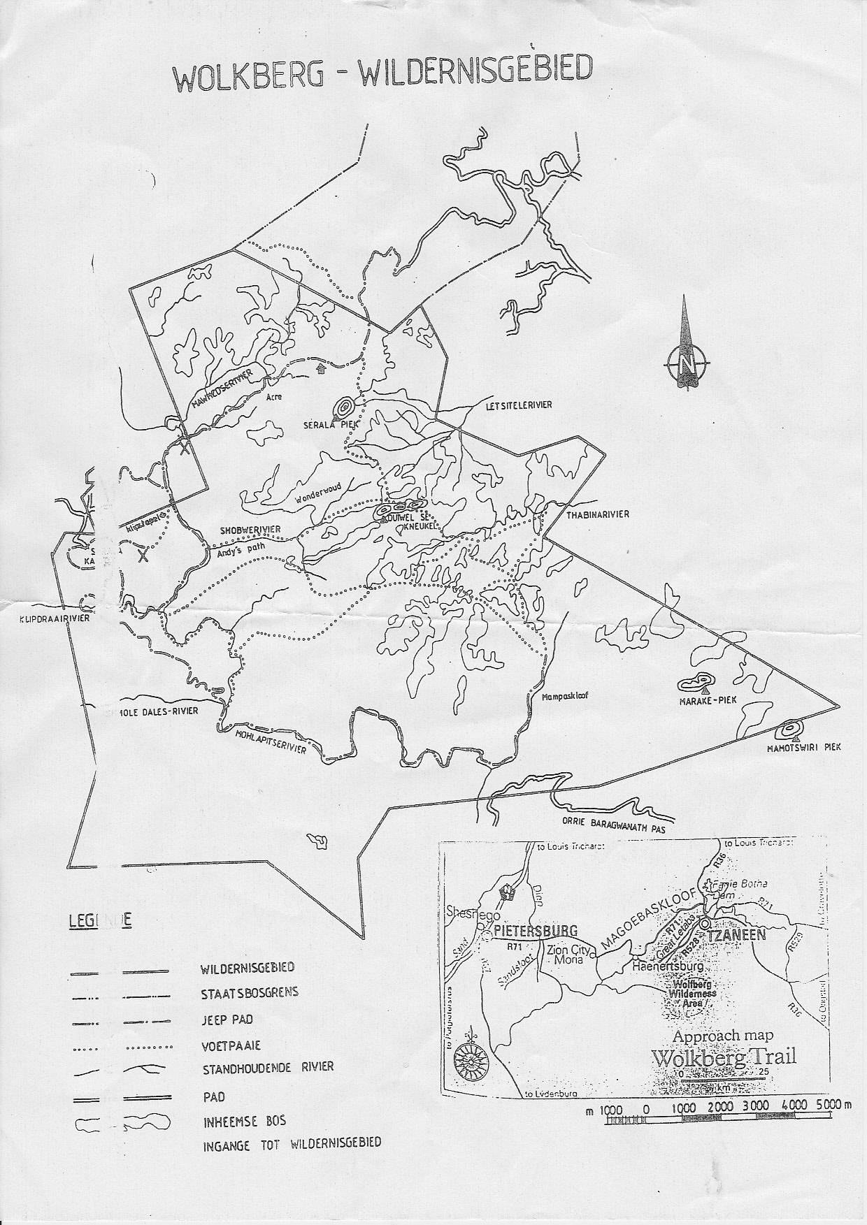
Maps
The below maps may help you to plan / navigate your trip to the Wolkberg.| Google Earth MapLast Update: 26/09/2023 | |
| Opens with Google Earth. Be sure to read the "Read Me!" on the map! Quick 2019 Update: A clear path has been cut along the Mohlapitse all the way from the Klipdraai Waterfalls up to the Bumbslides (taking into account that a section of this is jeep track), making these routes much quicker and easier. |
|
| Topographical Map | |
| Map from the Office of the Surveyor General. | |
| Contour Map (with routes) | |
| From the School for Mountain Leadership site (disclaimer on the linked page). | |
| "Official" Map | |
| The "official" map, available from the Serala Forest Station. Please do not use this map. It is horribly outdated and also extremely unclear. |
|
Links
Wolkberg Wikipedia PageGuided Wolkberg Trips
Footprint Hiking Club Wolkberg Page
First Trip
If you have never been to the Wolkberg before, then the following may assist you with planning your first trip:The turnoff to the Wolkberg is on the R71 between Pietersburg/Polokwane and Tzaneen, just after Zion City Moria when coming from the Pietersburg/Polokwane side. The turnoff is signposted. The road is mostly gravel and passes by a few small villages before ascending the mountain. Just keep going straight, and once on the mountain keep an eye out for any signs directing you to Serala Forest Station. If you're unsure then check the Google Earth Map. If you have a GPS, then the road should be marked on it.
At the Serala Forest Station, drive past the campsite and park your vehicle under the shady trees at the office and sign in to the mountain register. Sometimes there is nobody available at the office - don't worry, you can always pay when you get back from your hike. The cost is nominal - as of 2013 it is something like R10 per person per day.
2019 Update: It seems like fees have gone up significantly recently for some reason (we are still not sure why). Be prepared for R30/person/entrance, R30/car/entrance, R50/person/day. Please ask for an official pricelist and receipt.
You can overnight at the forest station campsite if you arrive late (an additional fee for camping at the forest station applies).
You are of course free to go wherever you like in the Wolkberg, but if you would like a safe and easy starting point then we recommend the following:
Simply walk down to the Klipdraai waterfalls. This is a safe and easy hike as well as an easy and popular campsite. From this "base camp" you can explore around and possibly try further hikes - perhaps up into the Wonderwoud. This will give you a good feel for the area and for Wilderness hiking/camping. To get to the Klipdraai waterfalls from the office; head back up the road and bear left towards the "compound", then just follow the road down towards the waterfalls! (The hike is approximately 6km with a 550m altitude difference.) After approximately 2.5km there will be a split in the road - take the left split. After approximately another 1.5km, you will cross a stream - an opportunity to get some fresh water, and/or even take a dip! Then just carry on down the rest of the way into the valley - you'll run into the campsite at the bottom.
Pictures
Whilst trying not to give too much away,here are some pictures of what you might expect to find in the Wolkberg:
 |
 |
 |
 |
 |
 |
 |
 |
 |
 |
 |
 |
 |
 |
 |
") |
Contact Us
If you have any queries about planning your trip to the Wolkberg (and would like to ask someone who has been there before), or if you have any comments regarding this page or the Google Earth map, then please email us at wolkberg@dizzy.co.za.We would like to share the following email which we received:
Dear Mr Dizzy
I am travelling to Wolkberg next week from Cheshire in the UK but I can't find very much information. Please could you help me with the following.
Sophia de Cheshire.
I am travelling to Wolkberg next week from Cheshire in the UK but I can't find very much information. Please could you help me with the following.
- Do you have the phone number of the Sherpas, as I need to give them instructions about caring for my £3,555 Rimowa Rucksack, which needs waxing everyday if exposed to sunlight.
- Are my white stiletto sandals ok footwear to walk on the footpaths.
- Are the pools heated.
- Do the coffee bars have Mochchocaloca Frapinos -or just Skinny Lattes.
- Are the snake enclosures secure.
Sophia de Cheshire.
Contact Serala Forest Station
Serala Forest Station should be available on +27 (0)15 276 9909 or +27 (0)15 276 9910.You can also try the forester in charge of the area, Frans, on +27 (0)72 779 1676.
Search and Rescue
Mountain Club of South Africa (MCSA) Search and Rescue (074 125 1385 / 074 163 3952)Disclaimer
This site is provided as a voluntary public service effort, and is not currently associated with any government or other institution. Whilst the information provided here is accurate to the best of our knowledge, we cannot accept any liability regarding it. Please make sure that you have read and understood the safety section thoroughly.| Site hosted by: |